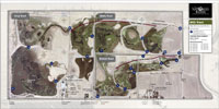
The Conservancy has long relied on aerial photos to assist in the habitat land management effort. As its preserve holdings have expanded, there has been an increasing need to identify specific features as reference points, to better educate contractors needed on the sites, and to avoid location mistakes. Accordingly, the Conservancy has begun the process of introducing “Tract maps” where an aerial photo is overlain with site-specific features.
The first such Tract map is of the combined Betts, Kismat and Silva preserves in the Conservancy’s Central Basin Reserve Area. Over time, additional tracts will be included. These will all be available in the “Helpful Documents” section of the Conservancy’s web site.

